The best map of Ireland poster depends on whether you want a travel-planning aid, a geography display, or heritage-inspired wall art. Maps International is best for finding attractions and trip ideas; Tiger Moon’s physical map suits geography learners; its pictorial map highlights well-known places in colorful illustrations. For a framed historical look, choose Lone Star Art, while Palmetto Posters offers a larger laminated display.
| Poster | Best for | Key feature |
|---|---|---|
| Maps International Ireland Map | Travel planning | Tourist attractions and transport network |
| Tiger Moon Physical Map | Geography learning | Terrain, rivers, cities, and roads |
| Tiger Moon Pictorial Map | Illustrated decor | Landmarks and colorful presentation |
| Lone Star Art 1844 Map | Heritage-inspired decor | Vintage design with an oak frame |
| Palmetto Posters Large Map | Large wall display | 24-by-31-inch laminated poster |
Maps International Ireland Map

This 16.5-by-23.4-inch laminated Ireland poster combines geographic information with visitor-focused points of interest. Its features include UNESCO World Heritage sites, castles, historical locations, nature reserves, mountain peaks, and other attractions. It also shows topography and the major transport network.
Best for: Travelers planning an Ireland itinerary or displaying reminders of places to visit. It was selected for its mix of landmarks, terrain, and transport information, which makes it more travel-oriented than a purely physical map.
Consider: The listed description emphasizes attractions and general topography rather than detailed, specialist-level geographic information.
Tiger Moon Ireland Physical Map

This 16.5-by-23.3-inch paper-laminated poster focuses on Ireland’s natural geography. It shows terrain, elevations, rivers, coastlines, major cities, towns, and roadways. The clear visual presentation is described as suitable for learning, planning, or display.
Best for: Students, classrooms, and buyers who want to see Ireland’s landscape alongside its settlements and roads. Choose this map if physical features are more important than illustrated tourist attractions.
Consider: The product details do not list individual tourist sites or historical attractions, so it may be less useful as a sightseeing checklist.
Tiger Moon Pictorial Ireland Map

This 23.4-by-16.5-inch illustrated map presents Ireland’s physical features and notable places in bright colors. Named examples include the Aran Islands, Blarney Castle, Galway, and the Cliffs of Moher. It is printed on paper and finished with a gloss laminate.
Best for: Buyers who want a decorative, approachable map that calls attention to landmarks and places of interest. It is also a fitting choice for people exploring Irish geography or family connections.
Consider: Its pictorial style prioritizes visual interest; buyers seeking a highly detailed road or transport reference may prefer a different map.
Lone Star Art 1844 Ireland Map
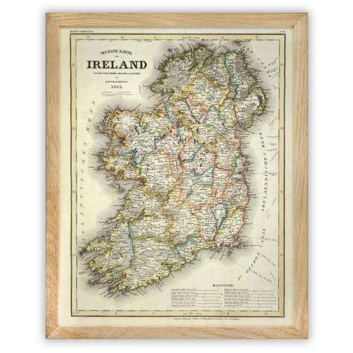
This 11-by-14-inch framed poster uses an antique cartographic design focused on historical Irish counties. The listed construction includes a natural solid oak frame, plexiglass, and MDF backing. It also has hanging hardware for display in either orientation.
Best for: People looking for Irish heritage decor, historical cartography, or a framed gift for a history or genealogy enthusiast. Unlike the laminated geography posters, it arrives as a framed wall-art piece.
Consider: Its vintage 1844 presentation is a decorative historical map, not the best choice for current travel planning or modern road information.
Palmetto Posters Large Ireland Map

This 24-by-31-inch poster is the largest option in this selection. It is printed on 36-pound photo matte paper and heat-sealed with lamination. The seller describes it as crease-free when shipped in a sturdy mailing tube, with tear- and fade-resistant properties. Its dimensions are described as fitting standard-size frames.
Best for: Buyers who want a larger map to serve as a prominent wall display. Choose it when viewing area and laminated protection matter more than a compact footprint.
Consider: The poster is unframed, so plan for separate framing or another display method if you do not want to hang it as-is.
Buying Guide: How To Choose An Ireland Map Poster
Do you need a travel map or a decor piece?
For trip planning, prioritize maps that identify attractions and transport details. The Maps International poster lists tourist sites and a major transport network. For wall decor, the pictorial map adds illustrated landmarks, while the 1844 print offers a framed antique look. These styles serve different purposes, so consider whether you need practical reference information or a particular visual mood.
Which map is best for geography learning?
Look for clear physical features such as rivers, elevations, coastlines, and terrain. Tiger Moon’s physical map specifically lists these details alongside cities, towns, and roads. The pictorial map also represents physical features but emphasizes landmarks and colorful presentation. For a classroom or study space, compare the information shown with the age and learning goal of the intended audience.
What size and finish should you choose?
Compare the available dimensions with your wall and intended viewing distance. Most options here are around 16.5 by 23.4 inches, while the Palmetto poster measures 24 by 31 inches. Laminated finishes appear on several maps and may suit buyers seeking a protected surface. The Lone Star Art option is already framed; the Palmetto poster is unframed.
Should you choose a current reference or historical map?
A current-looking geographic or tourist map is generally the more relevant format for planning and learning about present-day locations. A vintage map can be a better decorative fit for Irish heritage or historical themes, but its 1844 design should not be treated as a current navigation resource.
Frequently Asked Questions
What is the best Ireland poster for planning a trip?
The Maps International poster is a strong choice for travel planning because its listed features include attractions, historical sites, topography, and the major transport network.
Which Ireland map poster is best for a classroom?
The Tiger Moon physical map is suited to geography learning because it identifies terrain, rivers, elevations, coastlines, cities, towns, and roads.
Which Ireland map comes framed?
The Lone Star Art 1844 Ireland map is listed as a framed poster with a solid oak wood frame, plexiglass, and MDF backing.
Which option is the largest?
The Palmetto Posters map measures 24 by 31 inches, making it larger than the other listed posters in this selection.
Are these posters all laminated?
No. Several options are described as laminated, but the Lone Star Art product is described as a framed vintage poster. Check each product’s details for its finish and display format.